


Sendero rural de Galicia - PRG 94

Subida a Madroa, s/nTeis (San Salvador)36317 VigoPontevedraCampo LameiroSoutomaiorturismodevigo@vigo.org
This hiking route passes through Vigo, Soutomaior, Campo Lameiro, Cequeril, Luou and Santiago de Compostela. It can be partly followed by bike or horse.
Services
- Paneles informativos: Sí
Access
Access description Leave Vigo via the N-552 towards Teis and then follow signs for A Madroa.Signposting description The route is signposted by the Galician Mountaineering Federation
- ¿Existe transporte público para acceder al recurso?: Sí
- Accesos a pie: Sí
- Accesos para vehículos privados: Sí
Features
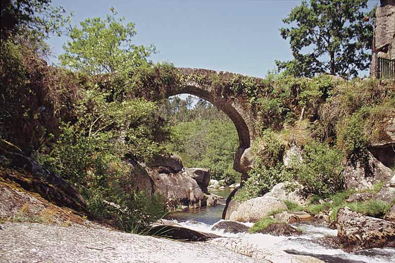
Places of interest along the route It offers panoramic views from A Madroa over the ría (‘estuary’) of Vigo and from Castro de Negros (a hillfort settlement) over the Maceiras River, Redondela and the cove of San Simón, as well as the Castle of Soutomaior and Pontesampaio in Arcade. Responsible body Galician Mountaineering Federation Starting point and destination The route starts and ends in A Madroa, parish of Teis. Description of the route The trail is located in the south of the province of Pontevedra and passes from Vigo to Santiago de Compostela. The starting point is the hill of A Madroa in Vigo, which offers views over the estuary of Vigo. Afterwards, the Castro de Negros in Pontevedra (a hillfort settlement) affords views over the cove of San Simón and the valley of the Maceiras River. In Soutomaior, the castle, a medieval fortress and Pontesampaio in Arcade are also noteworthy. After passing through the church of Rial and the bridge of Comboa over the Verduxo River, the bridge of Almofrei can be found nearby, surrounded by the beautiful landscape. The architecture of the area is rural, like the hórreos of Rascaderia (traditional raised granaries) in Cuspedriños and the church and rectory of Cequeril. There is also an oak grove, the Carballeira de San Xusto. There are petroglyphs on the way telling stories of the past. The route is also known as ‘Sendero de los Puentes’ (‘Path of the Bridges’). Recommended material Make sure you have warm clothes and plenty of food for this route. Cartography of the National Geographic Institute (IGN) 94-IV Santiago de Compostela, 120-II Extramundi de Abaixo, 120-IV Padrón and 152-II Caldas de Reis- Itinerario (M.I.D.E): 2
- Desplazamiento (M.I.D.E): 3
- Esfuerzo (M.I.D.E): 5
- Medio (M.I.D.E): 2
- Duración (días): 3
- Resource description: Hiking route
- Description of the surroundings: With panoramic views
- Tipología del Recorrido: Lineal
- Interés Paisajístico: High
- Dificultad : High
- Estado de la señalización: Very good
- Sombra: Sí
- Access on foot, by bicycle, on horseback, by motorcycle, by private vehicle
- Tipología de la ruta: Natural
- Estado de Conservación: Very good
- Length: 126 km